Reading time: 9 minutes
Presenting your project to the Urban Planning Advisory Committee (CCU) or the Architectural Integration and Implementation Plan (PIIA) team is a critical step for the profitability of your real estate investments. In Montreal, Laval, or Quebec City, municipal inspectors do not judge a sketch simply on its aesthetic merits, but on its strict regulatory compliance. Presenting austere two-dimensional (2D) plans slows down the analysis, creates doubt among committee members, and delays the issuance of your building permit. To eliminate this administrative burden, our studio GOCAM 3D provides services utilizing high-precision visual analysis tools. This comprehensive technical guide reveals how the rigorous integration of three-dimensional modeling transforms contentious files into convincing and unforgettable presentations. You will discover the meticulous requirements of urban planners and the scientific methodology to demonstrate the perfect alignment of your concepts with current zoning specification grids in Quebec.
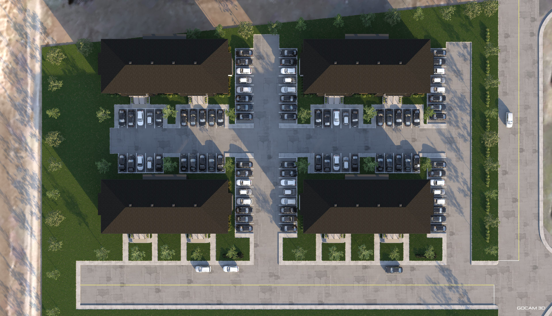
When you submit a major project on uneven terrain, municipal committee evaluation grids immediately target volume management and excavations. Flat topographical plans hide changes in relief, creating high uncertainty among urban planning technicians regarding erosion and surface water runoff. By using our topographic 3D renderings, you digitally materialize the contour lines from your land surveyor's surveys. These simulations allow elected officials to precisely visualize the finished ground floor elevation relative to the average level of the public sidewalk. According to a study by the Canada Mortgage and Housing Corporation (CMHC), a lack of clarity regarding the topographical impact of foundations is responsible for 34% of project deferrals during first readings at zoning committees. Our comprehensive 3D services resolve this issue by inserting the 3D-modeled buildings into an exact 3D virtual replica of the terrain with real elevation data. This allows you to demonstrate the precise height and relevance of your retaining walls, the preservation of mature trees along the perimeter, and a smooth transition toward adjacent properties. Visual analysis of grading and excavation work instantly reassures municipal engineers, as it proves that your concept respects the morphology of the neighborhood and the land without altering the sector's natural drainage. By mapping these variables, your request for a minor variance or regulatory amendment is backed by indisputable geometric facts, accelerating the procurement of your building permits. You shift from a position of justification to a demonstration of absolute technical mastery.

Technical omissions are the worst enemies of your regulatory approvals in urban planning. PIIA committees frequently reject real estate projects that conceal service infrastructure simply to embellish initial marketing perspectives. Commissioners demand complete transparency on the location of Hydro-Québec meter cabinets, emergency generators, semi-underground waste containers, and mechanical ventilation units (HVAC). By leveraging industrial and commercial 3D visualization through our 3D services, you integrate these mandatory elements right from the preliminary phase to prove their harmonious integration. We model the equipment in three dimensions based on your engineers' plans and create visuals with camera angles set at pedestrian eye-level from the street. This accuracy allows for the validation of your roof parapet thickness or the effectiveness of your architectural, vegetative, and metallic screens. Statistics from the Union of Quebec Municipalities (UMQ) indicate that clearly displaying service infrastructures in permit applications decreases the plan revision rate by 42%. By demonstrating with our 3D bird's-eye views that waste collection areas have adequate clearance corridors for municipal trucks, you prevent refusals due to functional non-compliance. This technical precision and level of detail showcase your professionalism and prevent the appearance of costly conditions precedent on your building permit—last-minute requirements that often force modifications to steel or concrete structures mid-construction. You thus secure your execution budgets while protecting the visual signature of the building and the final aesthetics of your property's facade.

The safety of road users and pedestrians is an absolute priority for civil engineering departments in Quebec municipalities. Every new underground parking entrance or commercial loading dock must meet strict requirements regarding visual clearance areas at intersections. Thanks to the creation of a dynamic 3D layout plan, the sight triangle is properly scaled and respected at the exit of your parking infrastructure. We precisely and faithfully position low walls, signage, curbs, and planting beds to demonstrate that no structure obstructs the field of vision of a motorist entering the public roadway. An analysis published by the Center for Urban Infrastructure Studies and Research (CERIU) shows that pedestrian collisions in dense environments drop by 27% when garage access undergoes three-dimensional geometric validation prior to construction. Furthermore, our 3D plans accurately reflect the maximum slopes calculated by architects and engineers for access ramps, in perfect compliance with the criteria of the Quebec Construction Code managed by the Régie du bâtiment (RBQ). By combining this data with 3D animations that include moving vehicles, you visually prove to municipal engineers that emergency or delivery vehicles can circulate freely on your site without encroaching on oncoming lanes. This visual detail neutralizes objections related to public safety, which is a frequent reason for rejection at political decision-making tables.
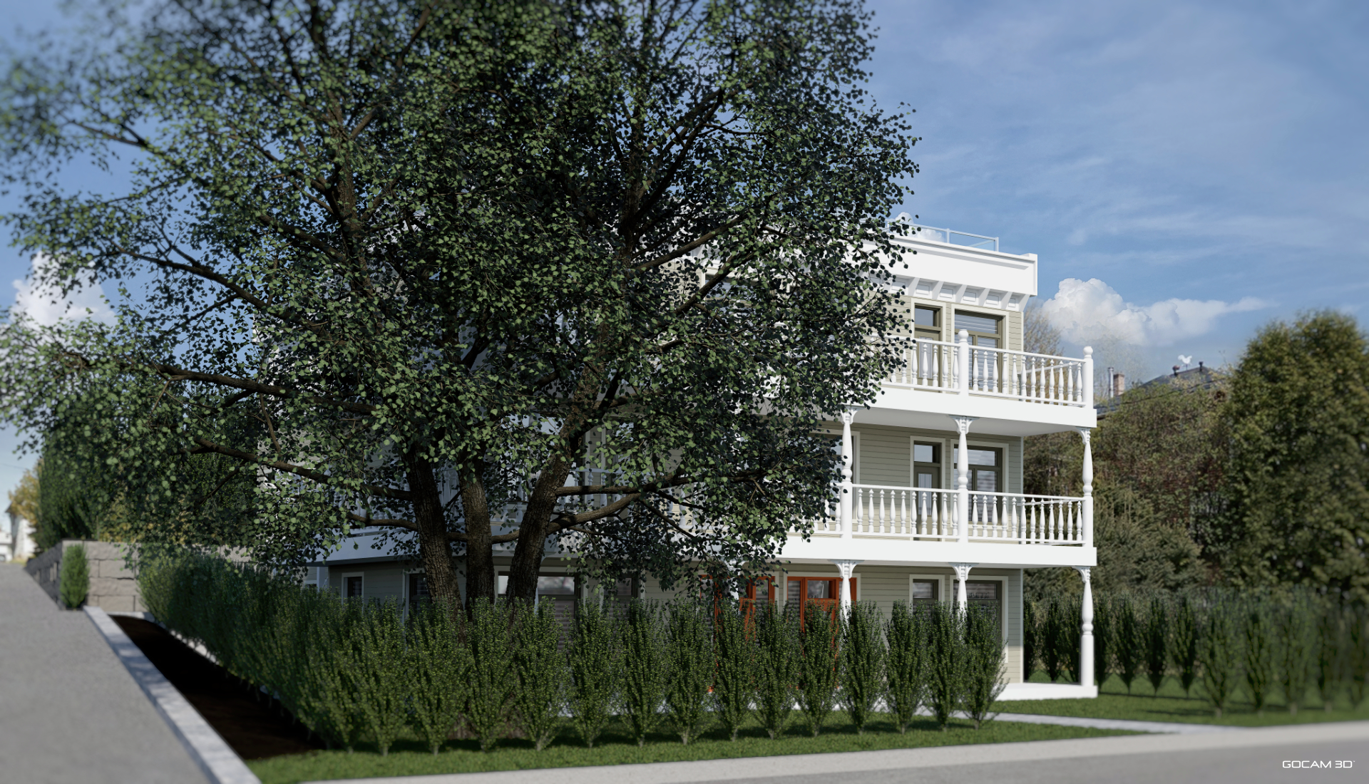
Inserting a multi-unit residential building or a commercial tower into a dense urban environment systematically sparks concerns about loss of natural light and privacy violations for adjacent residents. To reassure the CCU and calm community opposition, producing shadow studies through 3D renderings is indispensable. Our tools simulate real natural light based on the exact geographic location of your lot. You submit reliable visuals illustrating the actual impact of cast shadows on neighboring backyards and windows. Architectural research from the Université de Montréal (UdeM) confirms that presenting a rigorous shadow study accelerates the social acceptability of densification projects by 55% with neighborhood committees. Additionally, precise 3D modeling of property boundaries allows for the analysis of the direct relationship between your new openings and existing properties. You visually prove to the committee that the orientation of your balconies and the positioning of your windows respect the privacy of neighbors. If overlooking conflicts persist, we easily integrate appropriate technical solutions into the generated visuals, such as frosted glass screens or architectural louvers directly onto the 3D models. This level of technical detail demonstrates your respect for citizens' living environments and gives municipal officials the regulatory arguments required to publicly defend the relevance of your development project.

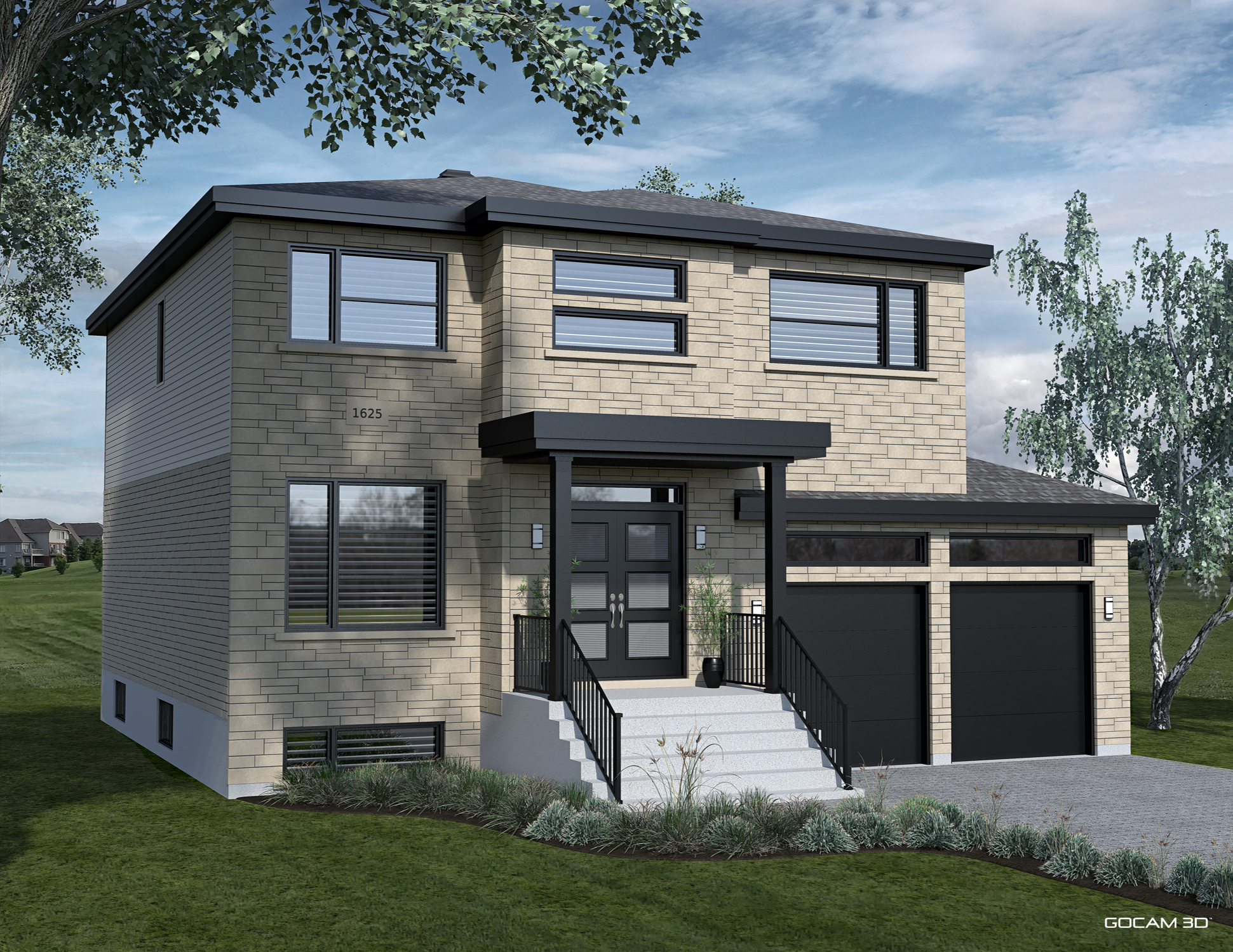
The analysis of materials is the central pillar of PIIA-type regulations in Quebec. Urban planning boards require an absolute match between the physical samples submitted and their appearance under various natural lighting conditions. Inaccurate illustrations mislead the committee, leading to systematic rejections for disrupting the harmony of the surrounding built heritage. Through our photorealistic 3D illustrations, we faithfully recreate the physical properties of textures: the reflection index of glazing, the roughness of masonry brick, the matte finish of fiber cement panels, or the grain of engineered wood siding. Our team configures these physical properties based on specifications and data sheets from your selected manufacturers. This technical rigor transforms each computer-generated image into a reliable contract document for public administration. Thanks to the use of promotional 3D videos, you can now showcase how materials behave at dawn, noon, and under an overcast sky typical of Quebec winters. This semantic versatility reassures committees that the building will maintain its architectural dignity across seasons, without creating glare for neighbors or passing motorists. By eliminating any subjective interpretation of textures, you lock in the compliance of your exterior building envelope and obtain your permits without having to go through multiple revision cycles for your exterior finishes.
Urban redevelopment projects frequently face public misunderstanding during consultation meetings required by the Act Respecting Land Use Planning and Development. Citizens struggle to decipher technical two-dimensional elevations, leaving room for irrational fears regarding the loss of visual landmarks in their daily environment. To defuse these social acceptability crises, our interactive immersion solutions prove to be powerful allies for your project. By deploying exterior interactive 3D tours around the perimeter of the future building, you offer residents and city council members the opportunity to navigate freely around the future real estate complex, eliminating mistrust through technological transparency. Complementing this toolkit with 3D bird's-eye views restores a comprehensive vision of landscaping, courtyard greening, and urban canopy efforts designed to combat heat islands. CCU commissioners greatly appreciate these immersive demonstrations because they prove you are not trying to hide anything. You transform a hesitant crowd into a constructive discussion panel, securing the support of local officials who finally have well-documented and accessible visual material to publicly validate the quality and integration of your project.
Winning the approval of an urban planning committee requires going beyond simple aesthetic appeal to deliver a rigorous technical demonstration. By turning three-dimensional simulation into a regulatory validation tool (slopes, visibility, sun exposure, materials), you respond precisely to the analytical criteria of Quebec's most demanding urban planners. Working with GOCAM 3D studio ensures a perfect translation of your engineering and architectural intentions into high-fidelity deliverables. This rigor cuts back-and-forth cycles with zoning divisions in half, avoids capital freezes, and secures the opening of your construction site within your scheduled planning windows. Entrust us with modeling your constraints to transform your regulatory challenges into powerful levers for municipal approval.
Written by Philippe Campagna-Vézina, President of GOCAM 3D inc. on 04/06/2026
A marketing image may subtly adjust the scale of elements or omit restrictive technical details to beautify the scene. A rigorous three-dimensional layout plan integrates actual surveyor coordinates, real infrastructure, and easements. It is an honest digital twin that serves as visual confirmation for municipal engineers to ensure compliance before work begins.
We work directly from color charts and technical data sheets of manufacturers selected by your architects. Whether reproducing historic clay brick or a specific masonry joint, our photorealistic processing accurately simulates light reflection, proving to the CCU that the sector's heritage identity is respected.
Urban planning boards impose strict quotas on greening and combating urban heat islands. Our aerial 3D renderings faithfully model the canopy, the positioning of mature trees, and the reflectivity of white or green roof membranes, providing immediate visual proof of compliance with the city's environmental regulations.
Yes. Our technologies can generate video fly-throughs that calculate the exact movement of shadows on adjacent lots, hour by hour, across all four seasons. This is the most powerful tool to close technical debates regarding loss of natural light and to reassure citizen committees during regulatory consultation processes.
Discover novelties, trends and our latest projects.